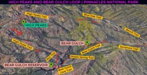
| Location: High Peaks and Bear Gulch Loop, Pinnacles National Park, California Distance: 7.4 miles (loop) Peak Elevation: 2,645 feet Elevation Gain: 1,833 feet Difficulty: Moderate Reminder: Bring water and a headlamp |
Bow wow wow yippee yo yippie yay! What an obstacle course of a hike! On a single route, you get a taste of all of Pinnacles National Park‘s best features. This loop takes you on a grand tour of the park. Go spelunking in Bear Gulch Cave, recline by the Bear Gulch Reservoir, and cling to rails among the iconic Pinnacles.
This is a challenging loop with prime views of the pinnacles and mountains of the High Peaks area. Including the Bear Gulch Loop adds 0.8 miles to the High Peaks Trail hike.
Directions to Trailhead
| From the 5 just north of Kettleman City, take exit 325. Turn left on Jayne Avenue and drive 10.6 miles. Continue on CA-33 N/E Polk Street and drive one mile. Turn left onto Elm Avenue and continue 33.9 miles on CA-133 W. Turn right onto CA-25 and continue 33.1 miles. Make a left turn onto CA-146 W and drive 3.8 miles. Turn left and drive 1.2 miles. Make a sharp turn. Park at the Bear Gulch Day Use Area. |
Hiking Directions
| Trailhead: Head west on Bear Gulch Trail. 0.4 miles: At the junction, turn left onto the Moses Spring Trail. 0.5 miles: At the junction, continue on the Bear Gulch Cave Trail. 0.8 miles: At the junction, turn right onto the Rim Trail. 1.2 miles: At the junction, turn left onto the High Peaks Trail. 2.5 miles: At the junction with the Juniper Canyon Trail, take the right fork to stay on the High Peaks Trail. 3.2 miles: At the junction with the Tunnel Trail, keep right to stay on the High Peaks Trail. 3.8 miles: At the junction with the Condor Gulch Trail, head straight on the Blue Oak Trail. 5.7 miles: At the junction with the Old Pinnacles Trail, turn right onto the Bench Trail. 6.3 miles: At the junction, turn right onto the Sycamore Trail. 7.4 miles: You have reached the end of the loop at Bear Gulch. |
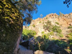
Bear Gulch Trail and Moses Spring Trail
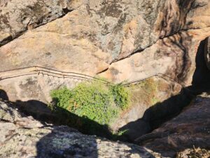
Get an early start because the Bear Gulch Parking area fills up fast. It might be cold when you start the hike, but it quickly gets hot and you’ll have to shed layers. The trail begins parallel to the road and then passes some picnic tables. From the Moses Spring Parking, the trail gently rises above Bear Creek, which is dry most of the year. At the junction with the start of the High Peaks Trail, follow the Moses Spring Trail to the left. Dense patches of moss and lichen cover most of the giant rock slabs beside the trail.
Bear Gulch Cave Trail
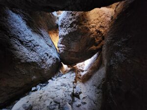
After a tall and large alcove in the rocks, you’ll see a sign reminding you to use flashlights. Through the slot, you’ll must crouch in the Bear Gulch Cave to avoid hitting your head on the low ceiling. The dark lower cave has a few really low spots and a couple stone staircases. You must turn to squeeze through some narrow spaces. After the bridge by the top, turn left and hike outside for a few minutes.
Next, you’ll enter the upper cave, where you’ll descend steps while hunched until Bear Creek. It’s like a game of limbo, but instead of a stick there’s a massive overhanging boulder. The path is easy to follow. Just look for the stone steps chiseled directly in the rock wall. A couple long stone staircases stick to the side of the monolith with protective metal railings for peace of mind.
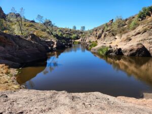
Bear Gulch Reservoir
One you climb out of the cave, stand on the dam for views of the reservoir. This is a great spot to explore or for a break by the water’s edge. When you’re ready to continue, climb above the intersection of the cave and dam bridge. Then, follow the Rim Trail for almost half a mile.
Climb to the Pinnacles
When you join the High Peaks Trail, this is where the hard work of the hike takes place. It’s about 1,000 feet of elevation gain in a mile. There are many signs with carabiner symbols pointing to rock climbing walls.
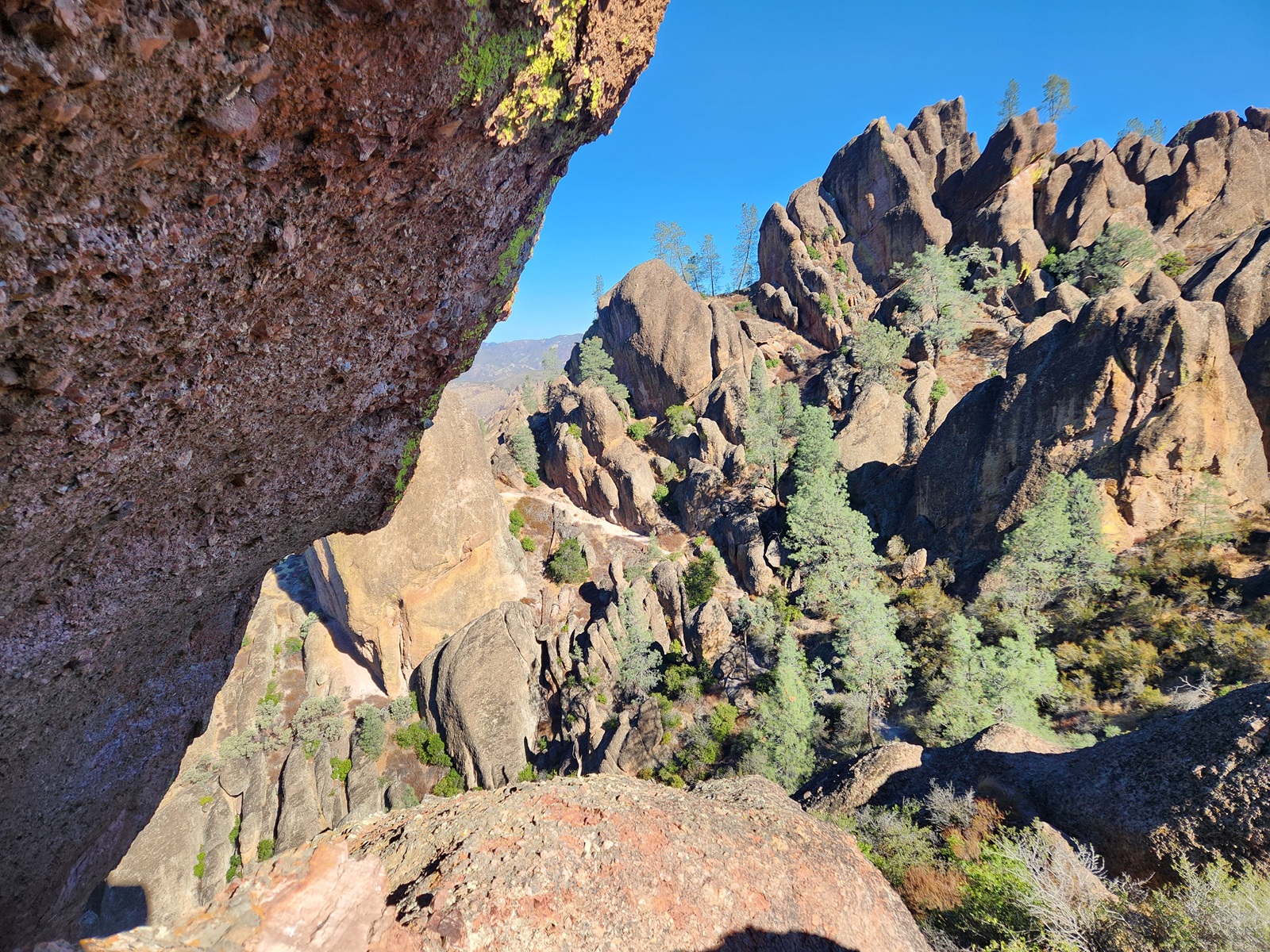
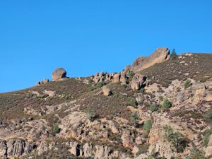
From a distance, you can start seeing pinnacles along the ridge. If you look closely, you can see climbers testing themselves on the rock faces.
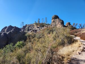
After an arch-shaped tunnel, there’s nine switchbacks leading to a bench and an outhouse on the saddle of Scout Peak.
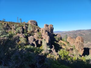
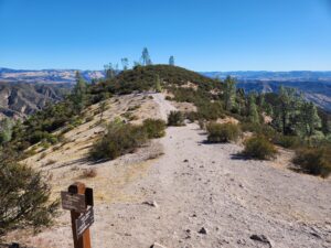
Standing on the Shoulders of Giants
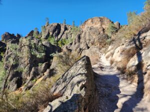
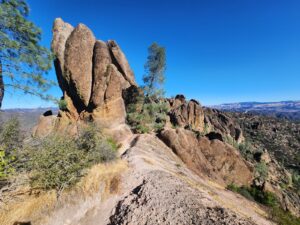
The High Peaks section is a ridgeline between Scout Peak and Hawkins Peak. This is the highlight of the park. The path hugs the top of the ridge, follows stone steps, and weaves around the pinnacles. It’s hard not to stop every few seconds to take photos of the rock formations above and below.
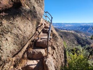
From the first metal railing, you have reached the steepest and narrowest part of the trail. In some spots, you are literally walking on the side of a pinnacle. The bulging rock leans so much over the steps that you have to lean over the railing to squeeze past. At the first ledge, you might be able to spot condors or turkey vultures riding the thermals. Then it’s a steep climb up steps to the high point of the ridgeline. I overhear a kid saying “the steps never end, there’s even more!” And he’s not wrong.
This is the fun part! Crouch, stoop, and lean to traverse the overhanging rock and steps cut in stone. The rails rein you in next to a drop of hundreds of feet. The final vertical climb down 20’ of square notches in the rock marks the end of the High Peaks section.
Blue Oak Trail
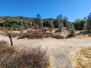
The conclusion of the High Peaks Trail is at the intersection of three trails. You can take a shortcut back to Bear Gulch via the Condor Gulch Trail. Or you can keep going on the Blue Oak Trail. This is the driest and hottest part of the hike – and also the easiest. Surrounded by rolling hills, the next two miles descends over a thousand feet.
Bench Trail
After the last stone steps to dry Chalone Creek, turn right onto the Bench Trail. It’s a relief from the heat with plenty of trees and pleasant shade. Gray squirrels scamper and forage in the trees. The path dips under Pinnacles Road. If parking is tight, you can always start the loop from Manzanita Parking, by crossing the creek bed. Actually, you can start this loop from any parking area in the park.
Sycamore Trail
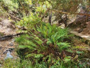
Head west on Sycamore Trail, which starts off flat and sunny with no shade. Then, it keeps to the right of Bear Creek and climbs 200 feet. At the bridge, there’s finally some water and green foliage. This final stretch is a perfect autumn scene, with a leaf covered path next to giant leafy ferns. One last little climb on a shaded path takes you to the employee cabins just before returning to Bear Gulch.