| Objective: Trek the ‘W’ Route in Torres del Paine, Patagonia, Chile Distance: 56.6 miles (one-way, like the letter ‘W’) Elevation Gain: 10,738′ Trip Length: 6 days Terrain: Mountain, river, forest, glacier Best time to visit: October to April |
Patagonia is the rugged and sparse southern end of South America. With its colliding continental tectonic plates, barren and shattered coastlines, it’s a geologist’s paradise. Steppes, fjords, and deserts surround the volcanic plateaus of the Andes mountains. Torres del Paine National Park in Chilean Patagonia has stunning cerulean lakes, glaciers, and the Cordillera Paine mountains. The ‘W’ trek zigzags through the Paine Massif, linking Las Torres, Valle Francés, and Glaciar Grey. With each refugio a day apart, you can sleep under a warm roof for the entire ‘W’. This is a backpacking adventure done in grand style – beds, hot meals, showers, and even the occasional cocktail.
- Base of Las Torres: This is a moderate ascent through the Asencio river valley and lenga beech forest. It is followed by a boulder scramble to Miradór Las Torres – the lakeside viewpoint beneath the three towers.
- Valle Francés: This is a ascent of glaciated Valle Francés for a 360-degree view of Los Cuernos and Las Torres.
- Glaciar Grey: The trail hugs the eastern side of Lago Grey, from Refugio Paine Grande to Refugio Grey. Glaciar Grey is part of the Southern Patagonian Ice Cap, the third largest source of fresh water in the planet.
| Day 1: Las Torres | Day 2: Lago Nordenskjöld | Day 3: Valle del Francés | Day 4: Glaciar Grey | Day 5: Glaciar Grey (Layover) | Day 6: Lago Grey to Lago Pehoé | Plan Your Visit | Video Tour |

Misty Mountain Hop to Las Torres (Day 1)
| Distance: 12.5 miles (day hike to Las Torres and back) Elevation Gain: 2,937′ |
Today, we are going on a day hike to Las Torres and back. The journey through Patagonia begins in a grassy plain with old wooden plank bridges. We wiggle through a narrow S-shaped fence that keeps out livestock. Then, we hike up a little hill covered with the red matchstick wildflowers of the firebush. During a short break, we also sample tart maroon berries.

The trail moderately ascends through the Rio Ascencio valley and enters a lenga beech forest. At a stream crossing, we scoop up water and drink it without treating it. It is surprisingly cold and refreshing. Where else can you find water this pristine?

The mountains on the other side of the valley have zebra stripes of snow and black rock. The trail climbs and hops over boulders.

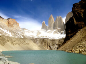
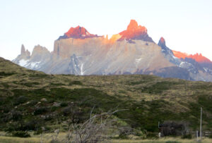
Above the gap, Las Torres’s (towers of the blue sky) granite needles dramatically reveal themselves behind a lake. We stop for a box lunch at the lakeside vista beneath the crown jewels of the Paine massif.
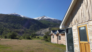
Refugios
Life is good at Refugio Las Torres. Refugios are log cabins with dorm style rooms, hot showers, and common area lounges with wood stoves. As a courtesy, you leave your boots in the hallway outside the room. The banquet hall serves local delicacies. For dinner, we enjoy ajiaco soup (meat, spicy peppers, cilantro), followed by spaghetti with Bolognese sauce, and a plantain mousse. There’s also a bar where you can buy soft drinks, wine, Austral cerveza flavored with local Calafate berries, and snacks. They say that if you eat a Calafate berry, you will return to Patagonia. The giant windows are in a perfectly position where we can watch the sun set below the mountain ridges.
Whole Lotta Lakes (Day 2)
| Distance: 9.7 miles Elevation Gain: 1,279′ |
During our first day of backpacking, we trek west (with full packs) past the trail leading up to the Torres. This morning, the path guides us down the middle of shrubbery shaped like giant green cotton balls.

At a stream crossing, we see a necklace of yellow Lady’s Slippers blossoms.

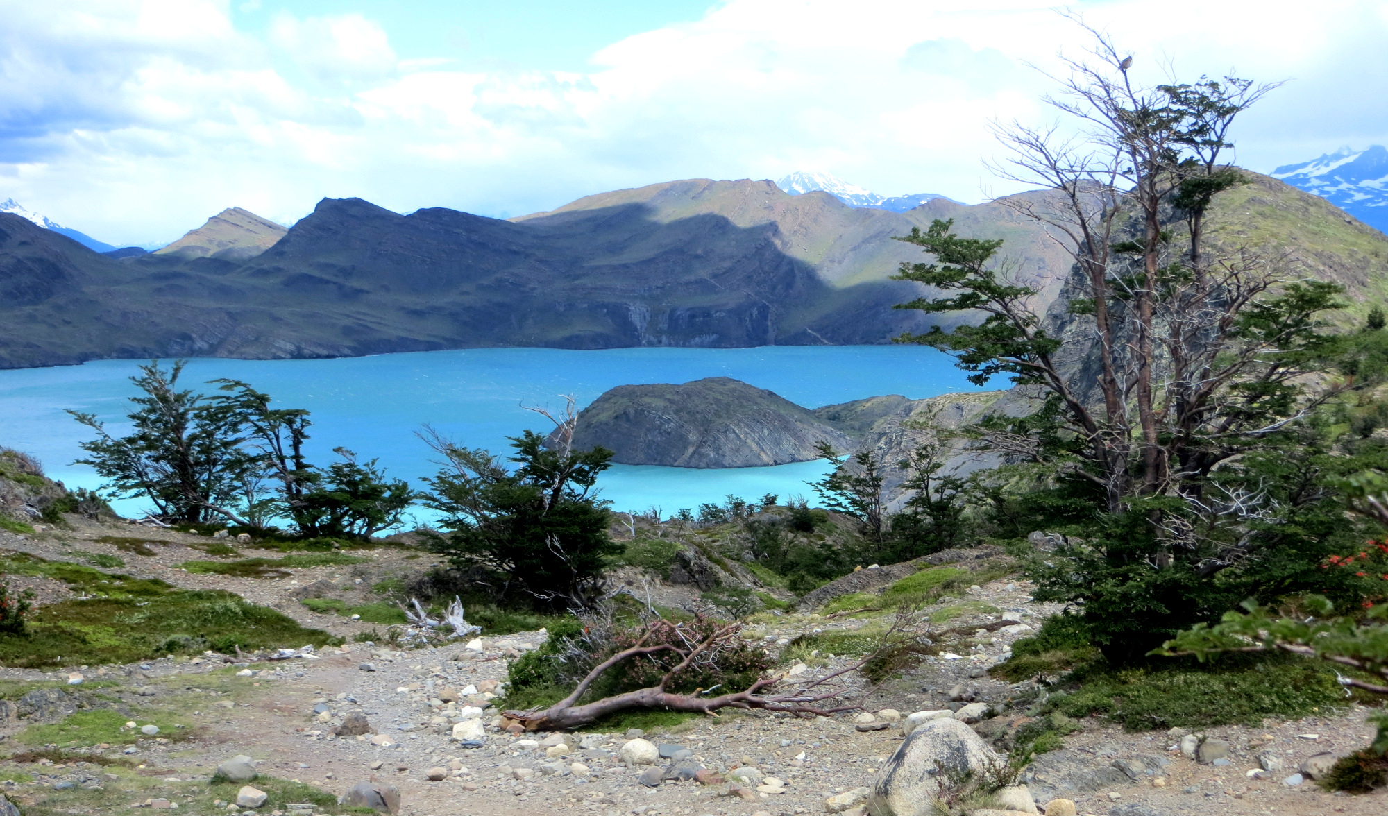
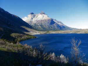
Lago Nordenskjöld
The trail rises to a saddle and curves down to Lago Nordenskjöld. We ramble between the northern shore of the lake and the base of Monte Almirante Nieto of the Paine massif. We stop for lunch by a stream next to a shattered suspension bridge. At the Erratic Rock (misheard as Erotic Rock), the entire group scrambles to the top for a fun photo op.


The wind whips fiercely across the lake. And with our large packs, it is possible to sail away. So we have to hunch low in the event of a strong gust. The powerful wind actually knocks down one of the hikers as she is negotiating the rocky path. At a pebble beach, we stop for a moment to skip stones. Occasionally, water ripples form, a refreshing spray of water kicks up, and a rainbow forms. Some of the trees here are short and hardy in order to withstand the zephyrs, and resemble stout bonsai trees.

Geodesic Domes
We haul our gear to the next refugio by Los Cuernos. Thanks to the quirky geodesic domes of the refugio, Domos Francés, we don’t have to carry tents or food.

The trail descends to the refugio, which is a cluster of green domes on stilts. These round domes have a metal skeleton in the shape of a Buckminsterfullerene molecule, aka Bucky Ball. They have a cloak of green tarp and cotton insulation. The domes even have round porthole windows, which make it seem like you are on a submarine. You climb a staircase to reach the elevated living space. Each bunk has its own outlet and light and there are plenty of places to dry your gear. This refugio is definitely the clear favorite of the group with its futuristic accommodations.
At the little dining cabin, we enjoy asparagus soup, a chicken drumstick, and a polenta dessert. After dinner, our group congregates on the floor of one of the domes and reflects on the day’s adventures.
Valle del Francés (Day 3)
| Distance: 13.5 miles Elevation Gain: 2,974′ |
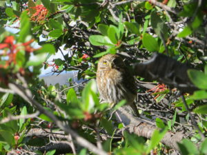
Today’s goal is to day hike north through Británico Forest to the amazing mountain amphitheater of Británico Forest. After a brief climb, we spot a tiny fist-sized owl hidden in a bush. We backpack to Campamento Italiano, where we drop off our packs and put the pack covers on. The packs look like colorful orange and yellow Easter eggs.

We head north up the glaciated and waterfall-cloaked Valle Francés. Los Cuernos are to the east, and Cerro Hoja and Cerro Mascara are the famous horned peaks (cuernos). They look like vanilla ice cream bars dipped in chocolate (and appear golden when the sunlight hits them just so).

Británico Forest has a clearing with soft brown dirt and dead tree trunks bleached white by the sunlight. The sun rays drip through the branches in beautiful kaleidoscopic patterns.


Británico Cirque
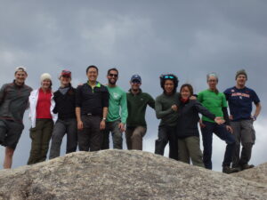
We continue to the northern end of the valley and arrive in a rocky outcropping at horseshoe-shaped Británico Cirque. Británico is a little pyramid in a sea of green with a few gigantic boulders at a spectacular viewpoint. Within the thin and pointy arêtes of the natural amphitheater, it looks like you’re standing in a broken wine bottle. I stand on the tallest rock and bask in the 360-degree view of the French Valley cirque. As if on cue, a couple Andean condors soar high above the mountain passes. The jagged peaks around us have hundred-foot layers of snow and ice.
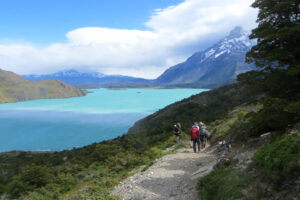
The way back down is steep and heavy on the joints. At the station, we retrieve our packs from the Campamento Italiano and march toward Lake Pehoé. The trail progresses past a muddy section via a series of wood slat bridges. After the trail bends above the lake, it’s a quick march to Refugio Paine Grande. Then, we retire for the night at Refugio Paine Grande next to Lago Pehoé. As an added treat, at the refugio, we spot giant hares sprinting under a full moon in Patagonia.
Glaciar Grey, the Bluest Grey (Day 4)
| Distance: 6.4 miles Elevation Gain: 1,049′ |
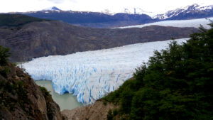
Today, we climb high above the eastern edge of Lago Grey. We will stop at Refugio Grey, by Glaciar Grey, where we will stay for the next two nights. While scampering over uneven terrain and rock outcroppings, we watch two fighter jets screech down the length of the lake. As we get closer to the glacier, we can see the first iceberg bits floating down the narrow lake.

Glaciar Grey is at the southern edge of the Southern Patagonian Ice Field, second largest ice field in the world. A wall of ice projects into the lake with its big blue fangs. Glaciar Grey provides quite a show with ice calving, cracking sounds, and avalanches kicking up flurries of ice and snow.

Glacial Ice Hike
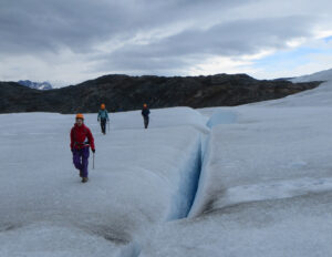
As a reward for reaching Glaciar Grey, after lunch, we embark on an expedition to ice hike on the glacier. Anyway, this is shaping up to be quite a mission. From the dock of Base Camp Grey, a zodiac boat whisks us across the lake. Then, there is a short hike across rugged rocky terrain to the edge of the glacier.
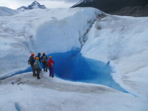
Equipped with ice axes, harnesses, crampons, and helmets, we finally walk on the wild Patagonian ice. We march past and incredible glacial features such as crevasses, streams, pools, and tunnels. The spellbinding blue glow of the ice caves calls to us. Suddenly, I am wandering inside the ancient blue cave. All in all, an adventure for the ages!

A Layover with Suspension Bridges and Kayaks (Day 5)
| Distance: 3.6 miles Elevation Gain: 730′ |
After finishing the ‘W’ trek, we are free to explore Glaciar Grey. There is a day hike to suspension bridges in the morning and kayaking in Lago Grey in the afternoon.
Hike to Suspension Bridges
This morning’s day hike visits a couple of suspension bridges over the two ravines east of Glaciar Grey. We hike through the forest and squeeze through overgrown portions. There are many clusters of orange orbs high up some of the tree trunks. Sabine picks some of these Indian Bread fungi for us to try. They are sweet and woodsy.
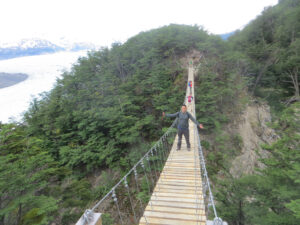
The first suspension bridge traverses a small gully. After crossing a stream and climbing a bit more, we reach a giant suspension bridge spanning a tall ravine. The steel cable bridge is very bouncy and the faster you move, the more it sways. From this bridge, you have a marvelous view of the glacier. The glacier looks like a giant used a knife to make cuts in the blue chunk of ice.

Kayak in Lago Grey
The afternoon’s kayaking trip is an exploration from Lago Grey to Glaciar Grey where the mountains meet the sea. The water is dangerously cold with icebergs bobbing in the small choppy waves. Just before reaching Glaciar Grey, we beach the kayak and walk in the glacier’s shadow.
To the Catamaran and Beyond! (Day 6)
| Distance: 6.4 miles Elevation Gain: 956′ |
The hike backtracks along the eastern shore of Lago Grey back to the northern catamaran dock on Lago Pehoé. After gently traipsing in the woods, the trail climbs to a spike above Lago Grey and then descends into a valley. Once you see Lago Pehoé, it’s not much further to the catamaran dock below Refugio Paine Grande.

Once the catamaran arrives, a stream of fresh hikers emerges, ready to tackle the ‘W’ in the opposite direction. Our line of hikers boards the catamaran and stows the packs. The catamaran cruises east through Lago Pehoé past granite spires to the north all the way to the park entrance. From the entrance, a bus drives down hilly roads past guanacos and flocks of rhea to Puerto Natales.

Puerto Natales is the gateway to Torres del Paine and it is where many hikers gear up for their trips. We grab some wood-fired lamb pizza and ice cream and walk around the charming town. After that, we catch a flight to Santiago.
Plan Your Visit
| Transportation: Catch a flight to Santiago, Chile. Fly to Puerto Arenas. Take a bus to Puerto Natales. Catch another bus to Torres del Paine. Lodging: Refugios are mountain lodges with mixed gender bunk beds and shared bathroom facilities. Food: Lunch and dinner offer carbohydrates (pasta and rice) and proteins (chicken and beef). |