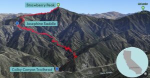
| Objective: Summit Strawberry Peak, San Gabriel Mountains, California Distance: 6.3 miles (out and back) Peak Elevation: 6,164′ Elevation Gain: 2,650′ Difficulty: Strenuous Caution: Class 3 exposure, poodlebush, rattlesnakes, heat |
The Colby Canyon Trail follows Colby Canyon up to Josephine Saddle. From the saddle, you can hike to Strawberry Peak, Josephine Peak, or both. The use trail (mountaineer’s route) follows a ridgeline around rough, rocky terrain and poisonous poodlebush plants. Beneath the summit, there is some intense Class 3 bouldering with exposure. Celebrate the effort with strawberries at the top of Strawberry Peak.
Directions to Trailhead
| From the 210 East in La Cañada, drive 9.5 miles on Angeles Crest Highway (CA-2) until the Angeles Forest Highway intersection. Continue driving one mile (passing the Switzer parking area on the right) on CA-2. There are two small dirt lots on the north side (left) of the road at Colby Canyon, marked with trailhead signs and distances. |
Directions to Summit
| Trailhead: From the trailhead, the Colby Canyon Trail enters Colby Canyon. 0.80 miles: The trail crosses the stream again and gently rises. 2.01 miles: At Josephine Saddle, turn right and follow the trail northeast about 30 yards. 2.03 miles: At the junction, follow the use trail (mountaineer’s route) on the right to access the western ridge. 2.90 miles: At this point, the path is rocky with some class 3 climbing. The route is spray-painted on the rocks. 3.15 miles : You have reached Strawberry Peak. Turn around and head back. |
Trek Highlights
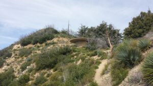
The first half mile of Colby Canyon Trail is shady and crosses the stream a few times. The next section climbs up and out of Colby Canyon through rolling green hills. Then the trail climbs a few switchbacks to Josephine Saddle. There is a water tank at Josephine Saddle.
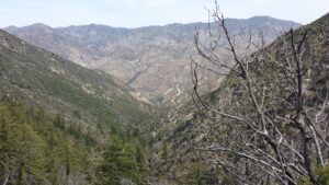
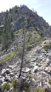
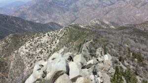
Follow the ridgeline via a steep use trail (mountaineer’s route). Hike east along the ridge until reaching a buttress on the north side. At the buttress, you cling to the side of some Class 3 boulders above a slippery sandy slope. There are a couple more hills and the inclines and declines are grueling. There is also some slight boulder hopping before the trail marches up the final stretch of the ridge.
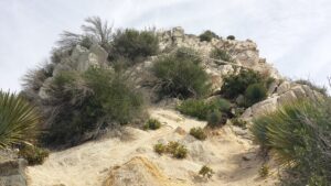
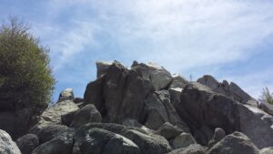
The trail ends and becomes an exposed Class 3 vertical climb up the last 500′ of the western face. There are about twenty minutes of bouldering straight up, and luckily there are spray-painted arrows to steer you in the correct direction. The summit has a register that you can sign. The final climb up the face is definitely the highlight of the hike, but it is extremely exhausting in both directions. The water tank is the perfect place to rest in the shade and enjoy views of the ridge.
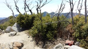
Remember to bring plenty of water as most of the hike is extremely exposed to the sun. Long pants are a good idea as there are many poisonous plants on this hike. You may also want to bring a helmet for the Class 3 sections.
Red Tape
Display your adventure pass.
Factoids
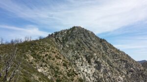
The mountain’s name comes from its resemblance to an upside-down strawberry. On most clear days, Strawberry Peak is visible from the LA basin, appearing as a round bump behind San Gabriel Peak and Mt. Wilson.
Photos