| Objective: Summit South Mt. Hawkins and Middle Hawkins, San Gabriel Mountains, California Distance: 12.8 miles (out and back), 13.2 miles (including side-trip to Middle Hawkins) Peak Elevation: South Mt. Hawkins: 7,783′, Middle Hawkins: 8,505′ Elevation Gain: 2,300′ Difficulty: Strenuous |
Hawkins Ridge is like four bumps on a log: Mount Hawkins, Middle Hawkins, Sadie Hawkins, and South Mount Hawkins. The Hawkins summits are at the heart of the San Gabriels, a remote sanctuary in the wilds of the back range. To get to Hawkins Ridge, you need to traverse across the Islip-Hawkins Ridge first. Hiking from Dawson Saddle is shorter than Islip Saddle; however, the road to Dawson Saddle is usually closed in winter. So, sometimes you may just want to start from Islip Saddle.
Directions to Trailhead
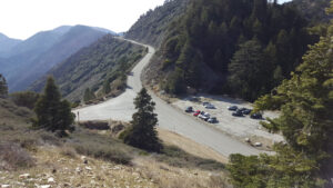
| From the 210 East in La Cañada, drive 40 miles on Angeles Crest Highway (CA-2), past two tunnels. Park in the large parking lot at Islip Saddle on the left (north). |
Directions to Summit
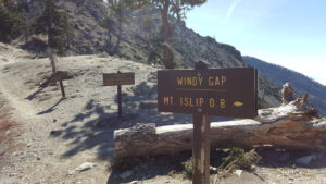
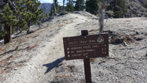
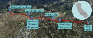
| Trailhead: From the east end of the parking lot, cross the road, and locate the trailhead for the Pacific Crest Trail (PCT). The trail immediately rises up some switchbacks. 1 mile: At the junction with Little Jimmy Road, cross the road and stay on the PCT. 2.2 miles: Little Jimmy Campground is on the right. 2.4 miles: At Windy Gap, continue east on the PCT along the ridgeline. 3.8 miles: At Hawkins saddle, turn right (south) onto the Hawkins Ridge Trail. 4 miles: At the saddle, turn right to climb Middle Hawkins. Then, turn left to stay on the Hawkins Ridge Trail. (The spur trail to the top of Middle Hawkins adds 0.4 miles to the trip.) 5.6 miles: At the dirt road, keep to the left (east) of the bump. 5.7 miles: At the South Mt. Hawkins saddle, the road begins to climb the western face of the mountain until it spirals to the top. 6.4 miles: You have reached South Mt. Hawkins. Turn around and head back. |
Trek Highlights
From Islip Saddle, the PCT rises above the Angeles Crest Highway. The trail is soft and wide until the first junction with Little Jimmy Road. A crunchy, light brown, pine needle rug covers the trail. There are still some patches of snow before Little Jimmy Campground.
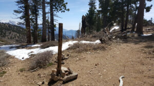
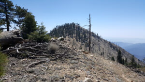
Once you reach Windy Gap, the ridgeline between Mt. Islip and Mt. Hawkins is steep and still heavily blanketed with snow in late spring. A misstep could result in a slide down the icy slope. Once you cross the trail junction to Hawkins Ridge, which extends to the south, the PCT takes a slight dip.
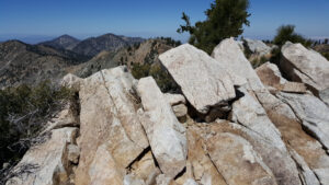
At the Hawkins Saddle trail junction, the Hawkins Ridge Trail forks to the south. This is the turnoff for Middle Hawkins and South Mt. Hawkins. Hawkins Ridge is like three bumps on a log: Sadie Hawkins, Middle Hawkins, and finally South Mount Hawkins. The trail immediately dips a bit and then approaches the high point of the ridge. At the saddle, turn right to climb Middle Hawkins and turn left to stay on the Hawkins Ridge Trail. (The spur trail to the top of Middle Hawkins adds 0.4 miles to the total trip.) At this point, you can decide to climb Middle Hawkins or not.
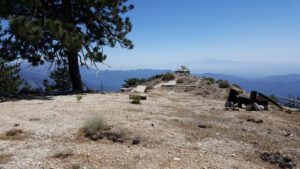
The Hawkins Ridge Trail hugs the eastern edge of the ridge and passes Sadie Hawkins. Stroll through a meadow until you reach the Hawkins Truck Trail (3N07). At the South Mt. Hawkins saddle, the road begins to climb the western face of the mountain until it spirals to the top. Explore the ruins of the wooden fire lookout tower at the summit.
Red Tape
Display your adventure pass.
Factoids
Nellie Hawkins was a waitress who worked at the bygone Squirrel Inn. This was in a booming goldmining area located in the North Fork of San Gabriel Canyon.
Photos