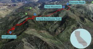
| Objective: Summit Pine Mountain and Dawson Peak, San Gabriel Mountains, California Distance: 10 miles (out and back) Peak Elevation: Pine: 9,648’, Dawson: 9,575′ Elevation Gain: 3,500′ Difficulty: Strenuous |
The North Backbone Trail begins near Wrightwood at the eastern edge of the San Gabriels. It connects Pine Mountain and Dawson Peak along a rocky rollercoaster spine. The trail eventually links up with Mt. Baldy, where it transforms into the Devil’s Backbone with steep drop-offs.
Directions to Trailhead
| From the Angeles Crest Highway (CA-2) in the town of Wrightwood, turn south onto Pine Street. Use the public parking lot between the bank and Pine. Walk south on Pine. Turn right on Partridge. Turn left on Acorn Drive. Follow Acorn until you reach a large “private road” sign on the right. Do not park your car beyond the sign as it will be towed away. The trailhead is another 1/2 mile beyond the sign. Walk to the end of the paved road. There is a gate where a dirt road continues. Follow the dirt road until you see the signed trailhead. (This walk adds a total of 2.6 miles and 588′ of elevation gain to the hike.) |
Directions to Summit
| Parking: Walk 1.4 miles to the trailhead. Trailhead: From the Acorn trailhead, the trail climbs Acorn Canyon. The trail continues climbing gradually to the top of Blue Ridge. 1.9 miles: Turn left onto the Pacific Crest Trail (PCT). 4 miles: The trail passes Pine Mountain on the right. 4.9 miles: Leave the trail when it turns to the Dawson-Baldy saddle and climb to the top of Dawson Peak. 5 miles: You have reached Dawson Peak. Turn around and head back. |
Trek Highlights
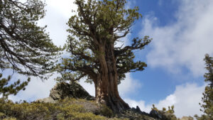
This is essentially a hike through Wrightwood’s beautiful cabins to the 3rd and 4th highest peaks in the San Gabriels. From the Acorn trailhead, the trail climbs Acorn Canyon and then traverses the ridge separating Acorn Canyon and Heath Canyon. The trail rises gradually to the PCT along the Blue Ridge.
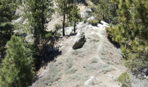
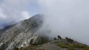
The North Backbone Trail is a relentless rollercoaster that begins with an immediate dip. The trail is much harder when you veer off trail as it becomes steep and slippery. The north face of Pine Mountain is covered in scree interspersed with lines of snow. This round trip will require you to ascend and descend Pine from both the north and the south. On your way up, you may see bighorn sheep dancing along the trail.
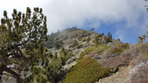
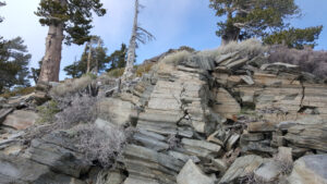
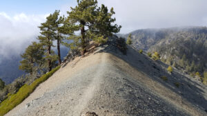
The trail drops significantly to the saddle between Pine and Dawson, but the grade is smooth and relatively easy. Near the top, it sounds like you are walking on dinner plates. Dawson Peak also has a summit register. From your solitary perch, you can see the crowd at Baldy.
Factoids
The peak was named in 1920 after Ernest Dawson, an influential early member of the Sierra Club. Dawson’s son Glen went on to establish some of the hardest rock climbs of the day, including the Mechanics Route at Tahquitz Rock, and the East Face and East Buttress routes on Mount Whitney.
Photos