| Objective: Summit Mt. Hawkins, San Gabriel Mountains, California Distance: 8.4 miles (out and back) Peak Elevation: 8,850′ Elevation Gain: 2,200′ Difficulty: Strenuous |
The trail to Mt. Hawkins rises above the Angeles Crest Highway until it reaches the ridgeline. From the ridge, the path makes a beeline to the summit. Even in late spring, the ridge can be covered with snow and ice, so you may want to bring cramp-ons. Hiking from Dawson Saddle is much shorter than Islip Saddle. However, the road to Dawson Saddle is usually closed in winter. Mt. Hawkins is at the heart of the San Gabriels with views of the towering peaks of the back range.
Directions to Trailhead
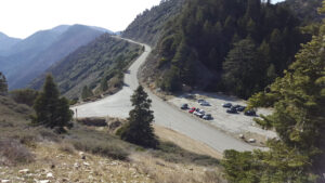
| From the 210 East in La Cañada, drive 40 miles on Angeles Crest Highway (CA-2), past two tunnels. Park in the large parking lot at Islip Saddle on the left (north). |
Directions to Summit
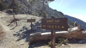
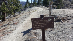
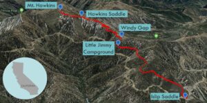
| Trailhead: From the east end of the parking lot, cross the road, and locate the trailhead for the Pacific Crest Trail (PCT). The trail immediately rises up some switchbacks. 1 mile: At the junction with Little Jimmy Road, cross the road and stay on the PCT. 2.2 miles: Little Jimmy Campground is on the right. 2.4 miles: At Windy Gap, continue east on the PCT along the ridgeline. 3.8 miles: At Hawkins Saddle, there is a ridge trail that forks to the south. This is the turnoff for Middle Hawkins and South Mount Hawkins. Keep going straight on the PCT. 4.17 miles: Leave the PCT and climb up a steep use trail along the western face of the summit. 4.23 miles: You have reached Mt. Hawkins. Turn around and head back. |
Trek Highlights
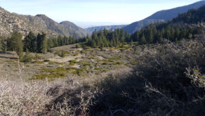
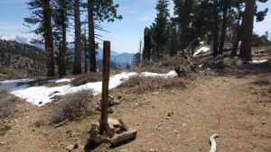
From Islip Saddle, the PCT quickly rises up some switchbacks and then levels off. The trail is soft and wide until the first junction with Little Jimmy Road. There are still some patches of snow before Little Jimmy Campground.
Once you reach Windy Gap, the ridgeline between Mt. Islip and Mt. Hawkins gets rather steep and is still heavily blanketed with snow in late spring. The trail is mostly hidden and a misstep could cause you to slide a great distance down the snow covered slope to the left. Once you cross the trail junction to Hawkins Ridge, which extends to the south, the PCT takes a slight dip.
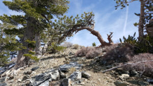
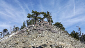
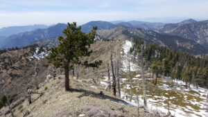
You continue following the Islip-Hawkins ridgeline until the PCT veers left away from Mt. Hawkins. Leave the PCT and follow the steep use trail up the western face of the summit. While this spot is remote from the city, it is at the heart of the San Gabriels. From the summit, you can see Mt. Islip, Mt. Baden-Powell, and Mt. Baldy.
Red Tape
Display your adventure pass.
Factoids
Nellie Hawkins was a waitress who worked at the long-gone Squirrel Inn located in the North Fork of San Gabriel Canyon, once a booming goldmining area.
Photos