| Objective: Summit Mauna Kea, Big Island, Hawaii, Pacific Ocean Distance: 12.6 miles (out and back) Peak Elevation: 13,796′ Elevation Gain: 4,600′ Difficulty: Strenuous Terrain: Shield volcano, alpine, montane forest, tropical dry forest |
Mauna Kea is the world’s tallest mountain – too bad over half of it is underwater. It is the largest of five volcanoes on the Big Island of Hawai’i. If you follow the line of the Hawaiian archipelago, you can glimpse into the future of the Big Island. The Pacific tectonic plate’s drift away from the volcanic hotspot has eroded and submerged the older islands. While you can drive to the top of Mauna Kea, it is a grand adventure hiking to the top.
Directions to Trailhead
From Hilo, head west on the Saddle Road (Hwy 200). Just before Mile Marker 28, turn right on Mauna Kea Access Road. The Visitor Information Station (VIS) is about 6 miles up the road on the right side.
Directions to Summit
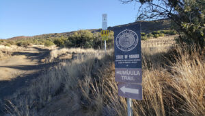
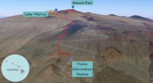
| Trailhead: From the VIS, turn right on Mauna Kea Access Road. Walk until you reach the 4WD road. 0.2 miles: Turn left onto the trail. 0.8 miles: Turn right onto the Mauna Kea Humu’Ula Trail. 4.3 miles: Turn left toward Lake Waiau. Stay on the trail to the summit. 4.9 miles: Turn left on Mauna Kea Access Road. 5.0 miles: Turn right to stay on Mauna Kea Access Road. 6.0 miles: You have reached the boundary below the sacred spot on the summit. Respect Hawaiian culture, and head back. |
Trek Highlights
Wait at the Visitor Information Station for 30 minutes in order to acclimatize properly for the hike. As the Sun wakes up, you rise above the cloud line where you can view indigo hues reflect off clouds. Watch shades of pink, orange, and gold begin to diffuse across the sky.
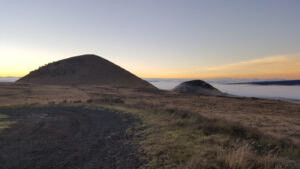
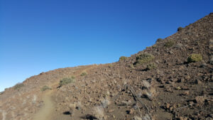
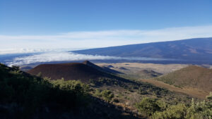
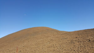
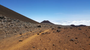
Once you climb past the Kilohana cinder cone and turn north, the trail quickly ascends and the vegetation falls away. Looking back, you see the colorful cinder cone valley between Mauna Loa and Mauna Kea. The otherworldly slope ahead is brown with a hint of red and covered with large rocks. You really get a deep sense of the remoteness and harshness of the terrain. It feels as if you could be wandering across a barren gradient on the Moon or Mars. This is the first of a series of rolling boulder fields. The ash-coated trail weaves past Pu’ukeonehehe’e and other cinder cones.
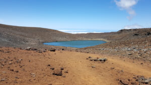
At the saddle of the Pu’uhaukea cinder cone, stop for selfies above the turquoise gemstone, Lake Wai’au. This is the highest lake in the USA and it is arguably the highlight during this hike.
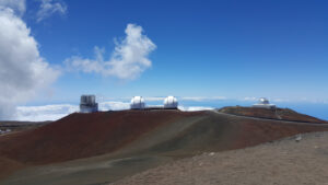
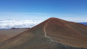
The last mile is a final push on a paved road via two consecutive U-turns to the frigid summit. A ring of observatories crowns the top of Mauna Kea. Show your respect for Hawaiian cultural and environmental values, by stopping at the sign 0.3 miles from the summit. Stop here and admire the view. The ancient Hawaiians spoke of the fire goddess, Pele, who sent blazing magma and set the sky ablaze. The snow goddess, Poli’ahu, thwarted Pele draping the lava flow with a snowy blanket. This mythic cataclysm must have emitted a thunderous roar as molten lava cooled and hardened to a crusty sputtering mess.
Red Tape
- Acclimatize at the Visitor Information Station (VIS) for at least 30 minutes at 9,200’. From the VIS, you can receive a weather update and register for the hike. For more information, go to: http://www.ifa.hawaii.edu/info/vis/
- A standard 2-wheel drive vehicle can reach the VIS. Take a 4-wheel drive vehicle if you want to go past the VIS.
- Bring 3-4 liters of water.
- Do not SCUBA dive 24 hours prior to hiking.
Factoids
Mauna Kea is the world’s tallest mountain at 32,696′. Water submerges the bulk (18,900′), which is why it is not the highest.
Photos