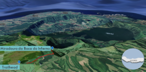
| Objective: Miradouro da Boca do Inferno, São Miguel Island, The Azores Distance: 1.5 miles (out and back) Peak Elevation: 2,600′ Elevation Gain: 350′ Difficulty: Easy |
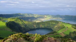
Boca do Inferno is the “Hell’s Mouth,” a giant volcanic scarred rupture on São Miguel Island in the Azores. Miradouro da Boca do Inferno is the viewpoint from the crater’s edge. You can view the interlocking crater lakes and calderas surrounding the village of Sete Cidades. The gems in this treasure are the Lagoa Azul and the Lagoa Verde, a blue lake and a green lake.
Directions to Trailhead
| Head west onto EN1-1A. Just before Ponta Delgada, head northwest onto R1-1A and continue for 2.8 km. Take the exit toward Capelas, turn right, and drive another 2.8 km. Turn left onto M503 and continue 4.8 km. Turn right at ER 8-1A and drive 8.1 km. Make a left at the parking area across from the trailhead. |
Directions to Summit
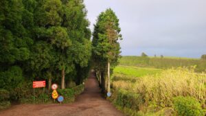
| Trailhead: Cross the street, pass the gate, and head north on the trail. 0.1 miles: At the junction, keep left to stay on the main trail. 0.6 miles: At the junction, keep left to stay on the main trail. 0.75 miles: You have reached the Miradouro da Boca do Inferno. Enjoy the viewpoint and return to the trailhead. |
Trek Highlights
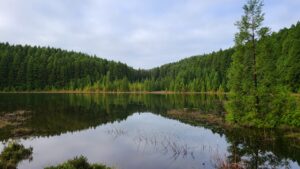
Tall juniper trees line the initial stretch of the red volcanic gravel path on either side. There are a couple spur trails to the left leading to Lagoa do Canário, a calm lagoon.
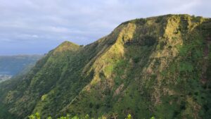
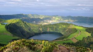
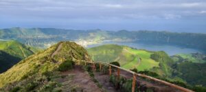
Suddenly, you can see the green rock walls of the Sete de Cidades massif rise up from the mists. The dirt trail unfurls like a red carpet in the middle of green vegetation with sharp drop-offs on both sides. The miradouro (viewpoint) just ahead seems to be floating in air in its prime viewing location. The big reveal at the miradouro is breathtaking as you finally see the iconic view of the twin lakes and the wall of the giant caldera encircling our entire vision.
Within this giant caldera is a network of craters within craters next to smaller calderas. Lagoa de Santiago is directly beneath inside a green volcanic crater. Lagoa Rasa fills a smaller crater on Santiago’s high rim to the left. Toward the back are the twin lakes of Lagoa Azul on the right and Lagoa Verde on the left. Depending on the time of day, the colors of the twin lakes are truer to their names. Right now, they both are a shade of blue-green. A narrow bridge separates the twins and leads to the small village of Sete Cidades, which is below Caldeira Seca, a small empty caldera. In the morning, the sunlight dances with clouds throwing golden rays on various parts of the lakes or green slopes.
Photos of Boca do Inferno