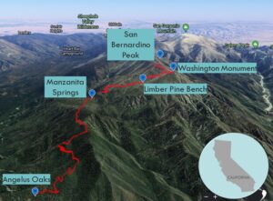
| Objective: San Bernardino Peak, San Bernardino Mountains, California Distance: 16 miles (out and back) Peak Elevation: 10,629′ Elevation Gain: 4,689′ Difficulty: Strenuous |
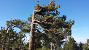
San Bernardino Peak does not receive as much attention as San Jacinto Peak, Mount San Gorgonio, and Mount Baldy. Yet, the trail has everything you want in a great altitude training hike: serious distance and elevation gain. It also provides a scenic journey through manzanita groves, wizened limber pines, and a historical monument.
Directions to Trailhead
| Head east on the 10 until Redlands, exit Orange Street. Turn right on Lugonia Avenue to follow Highway 38. Drive through Mentone, past the Mill Creek Ranger Station, and continue to Angelus Oaks. Look for a fire station on the right side and turn right onto Fir Street. Take an immediate left on Frontage Road. Continue past three houses and turn right onto a forest service road named 1Wo7. This slow and bumpy ¼ mile dirt road will reach a dead-end at the trailhead parking. |
Directions to Summit
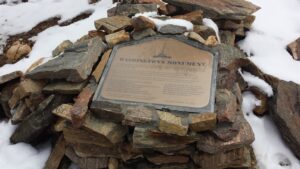
| Trailhead: From Angelus Oaks, the trail immediately climbs some switchbacks. 2 miles: You have reached the San Gorgonio Wilderness sign. 4.7 miles: Walk straight past the Manzanita Springs campground and the trail junction. 5.7 miles: There is a trail camp at Limber Pine Bench. 7.5 miles: There is a plaque commemorating Washington Monument. 8 miles: After reaching San Bernardino Peak (10,629′), turn around and head back. |
Trek Highlights
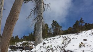
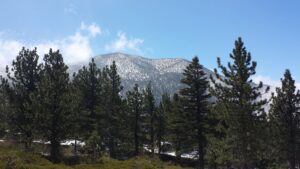
In May, there could still be fresh snow covering the trail. You might even see bear paw prints.
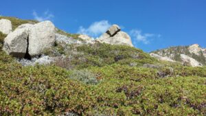
From the Angelus Oaks (5,960′) trailhead, the San Bernardino Peak Trail climbs up an initial hill. The long gradual switchbacks pass through a forest of pine, cedar, white fir, and black oak. After two miles, the trail begins leveling off a bit after the San Gorgonio Wilderness sign through manzanita-covered hills. The colors and the numbers of the manzanita are breathtaking.
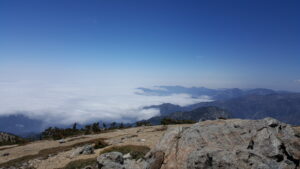
In another 2.7 miles, at Manzanita Springs (8,240′), there is a campground and trails from Johns Meadow and Columbine Springs. Keep going straight ahead. After the junction, the trail rises up slopes with rock formations and more manzanita. One mile farther, Limber Pine Bench (9,360′) has a trail camp and sensational views above a sea of clouds. In 0.25 miles, Limber Pine Springs is a dependable source of water. Then, the trail sharply climbs switchbacks.
In late Spring, during the last few miles to the top, the trail is thick with snow and wind. Every so often, quivering trees will shake, shiver, and scatter snow onto the ground.
After 2.8 more miles, there is a plaque commemorating Washington Monument (10,290′). The summit is now in sight. The trail climbs a final 0.5 miles, where it intersects a spur trail about 40 yards below the summit.
Red Tape
For day use, you need to obtain a wilderness permit from the San Bernardino National Forest Mill Creek Ranger Station in Mentone, by emailing the form found here to dayhike@swga.org. Display your Adventure Pass.
Factoids
In 1852, Colonel Henry Washington and an Army survey party were directed to place a monument on San Bernardino Peak, marking the earliest initial points of the San Bernardino meridian and baseline. The monument was the east-west reference for future surveys and subdivisions of land throughout Southern California.
Photos