| Objective: Hike to Potato Harbor, Santa Cruz Island, Channel Islands National Park, California Distance: 4.5 miles (out and back) Peak Elevation: 512 feet Elevation Gain: 522 feet Difficulty: Easy |
Santa Cruz Island is the largest island of the eight-island Channel Islands archipelago and in California. View Santa Cruz Island from above on its hiking trails or from below in a kayak. Hike along the bluffs high above Potato Harbor with spectacular coastal views of the points below.
Directions to Ferry | Take the Ferry | Directions to Potato Harbor | Trek Highlights | Plan Your Visit
Directions to Ferry
| Head northwest on the 101 N. Take exit 64 for Victoria Avenue and continue for 0.2 miles. Turn left onto S Victoria Avenue and drive 0.6 miles. Make a right onto Olivas Park Drive and continue for 2.4 miles. Keep going straight on Spinnaker Drive for 1.0 mile. Turn right into the large parking lot for Island Packers Cruises. |
Take the Ferry
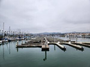
From Ventura, the ferry takes 1.5 hours to cross the Santa Barbara Channel with stops for viewing wildlife. It’s chilly on the top deck so bring a jacket and a hat. Once you pass the oil rigs, the bottom of the sea floor drops off a cliff. In the deep water, this is where you will spot large marine mammals. You see the outline of Anacapa’s sharp mountain ridge first. Then, you see Santa Cruz’s dark silhouette. The pier can only manage one ship at a time, so you may have to wait in the harbor. You disembark the boat at Scorpion Anchorage and a volunteer will provide a brief orientation on where to hike.
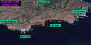
Directions to Potato Harbor
| Trailhead: Head west on Scorpion Valley Road. 0.45 miles: At the junction, turn right onto the Cavern Point Loop Trail. 0.72 miles: Turn left onto North Bluff Trail. 2.5 miles: You have reached the point above Potato Harbor. Return to Scorpion Anchorage. |
Trek Highlights
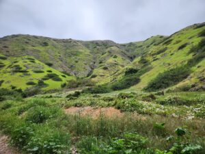
From the pier, Scorpion Valley Road passes Scorpion Ranch and a campground by a stand of eucalyptus trees. The hills are covered in different shades of bright green shrubs and chapparal. Cavern Point Loop Trail has a short incline to the edge of the cliff.
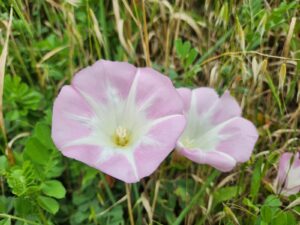
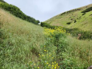
There are patches of yellow plants and pink Morning Glory flowers.
To the right, you can descend to Cavern Point and follow the loop back to Scorpion Anchorage.
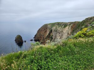
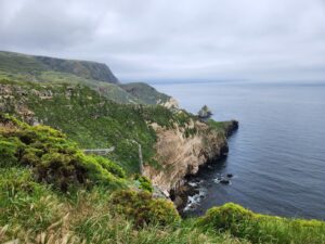
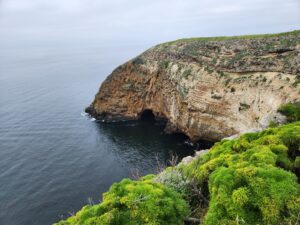
Turn left onto the North Bluff Trail, which hugs the edge of the cliffside. There are a few V-shaped notches in the coastline. From a couple viewpoints, you can see the jagged points jutting out into the ocean. Some points have eroded to miniature island rock outcroppings. The porous cliff walls have giant holes. At the base, you can see arches and openings to the sea caves.
The final section of the trail is a straight shot on a one-mile dirt path. I didn’t see any island foxes, but I notice some of their scat. The island fox supposedly reached the islands on rafts over 10,000 years ago. Due to island dwarfism, they evolved to the size of a house cat.
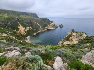
The end of the trail dips so you have a magnificent view of Potato Harbor. There’s a crescent sandy beach. The blue water is clear enough that you can see the rocks, kelp, and even the sea floor. This is the perfect spot for a quick lunch before heading back.
Plan Your Visit
| Vendor: Book both the ferry and kayaking trip from Santa Barbara Adventure Company:
Schedule:
|