| Objective: Summit Mount Democrat, Rocky Mountains, Colorado Distance: 5 miles (out and back) Peak Elevation: 14,148′ Elevation Gain: 2,150′ Difficulty: Strenuous Caution: Altitude sickness, lightning |
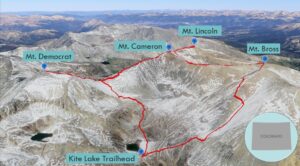
Mount Democrat is a fourteener that is located in the Mosquito Range of the Rocky Mountains, near Alma. The trail has some Class 2 boulders along the ridge. If the weather cooperates, you can do the Decalibron loop, which is a portmanteau of: Democrat, Cameron, Lincoln, and Bross. The Decalibron is only three miles longer than hiking to Democrat alone. Due to liability issues, you cannot currently climb Mount Bross. The ski resort town of Breckenridge is a good staging point for the climb.
Directions to Trailhead
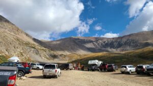
| From Breckenridge, head south on CO-9 and drive 15.4 miles. At Alma, turn right to head west on County Road 8/Buckskin Street. Continue 6 miles to Kite Lake. The dirt road is OK for the most part until the last mile. At the first permit station, go ahead and fill out a permit to avoid backtracking from the station at the lot in case you do not make it. Remember to bring a pen so that you can fill out the permit. And bring $5 cash. About a third of a mile from the lot, the road gets really cratered. A 2WD vehicle with good clearance can make it. If not, park to the side of the road, but do not block the road. There are toilets by the Kite Lake Trailhead. |
Directions to Summit
| Trailhead: Begin hiking on the Kite Lake Trail. 0.06 miles: At the junction, turn right. 0.07 miles: At the junction, turn left. 0.6 miles: At the junction, turn right. 1.7 miles: At the junction, turn left along the ridge onto Mount Democrat Trail. 2.5 miles: You have reached Mount Democrat. Turn around and head back. |
Trek Highlights
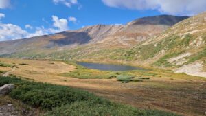
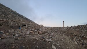
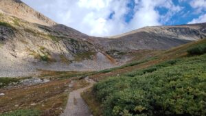
The trailhead is at the northern end of the parking lot. Fasten your headlamp and follow the line of lights. The trail rises gradually in a line alongside Kite Lake. Every once in a while, you will hear a squeaking pika. At the top of the green slope, there is an abandoned mine with just some shattered planks.
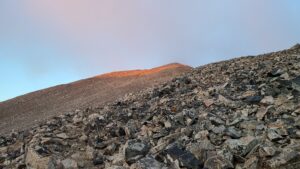
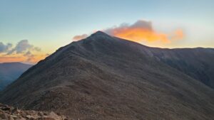
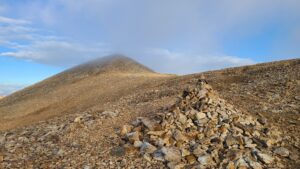
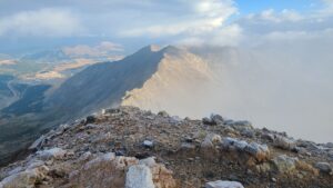
There are some little switchbacks leading to the ridge. At the saddle between Democrat and Cameron, it gets a little windy. There is some Class 2 scrambling up a rocky bump. Stick to the trail or the scrambling will be more difficult. Watch your footwork as the white frosty rocks are precarious prior to sunrise. The trail gets steeper at this point. Once you reach the visible highpoint, or false summit, the path levels off a bit and you can see the true summit. At the false summit, it is both a bit disheartening and uplifting at the same time. Soon, you are just below the summit and there is a short push to the top. There is a razor-sharp edge to Buckskin to the south and a jagged ridge to the northeast connecting to Cameron.
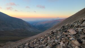
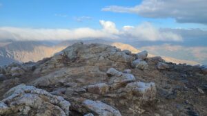
When the weather is right, you can continue on that ridge to Cameron, Lincoln, and Bross on the famous Decalibron circuit. However, due to liability issues, Bross, which is on private property, is off limits. Today, a storm is rolling in, so Cameron and Lincoln will have to wait for another day. On the way down, watch your step as it is really steep. In the darkness, you do not appreciate how green and yellow the valley is. There are plants that resemble red artichokes wedged between the rocks. Kite Lake is long and blue, a nice welcome back to the trailhead. On the way down the rocky road, there was a moose in the trees.
Photos